Filter

On the Go: USAID MEASURE DHS Data Available in New Mobile App

With pressure to base policies and programs on meticulously collected data, there is a need to make USAID funded Monitoring and Evaluation to Assess and Use Results Demographic and Health Surveys (MEASURE DHS) reports more readily available.  However, many developing countries have no access to a tangible library of DHS reports, nor a reliable internet connection to visit the MEASURE DHS website to access these surveys.

Luckily, the rapid increase in the mobile phone and smartphone usage  has given the MEASURE DHS team hope.  The popularity of these devices can grant anyone access to DHS reports, from policy makers in Washington, D.C. to remote communities in rural Africa.  In fact, according to Pingdom’s STATcounter, 15% of Africa’s internet browsing in May 2012 came from mobile devices, an increase of more than 150% from 2010.

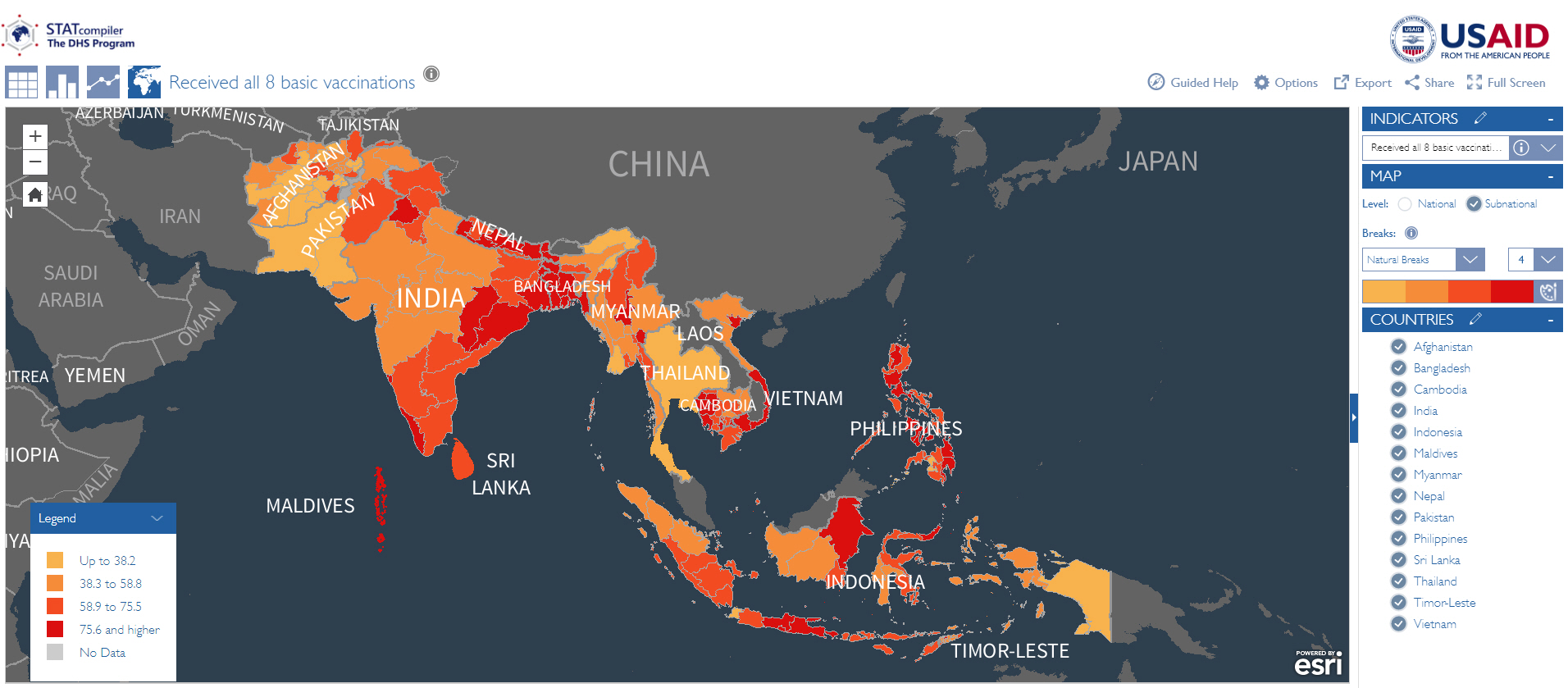
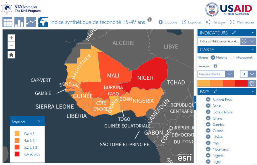
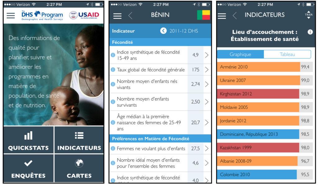
With the help of MEASURE DHS technology partner, Blue Raster, the DHS Mobile application was developed.  MEASURE DHS mobile covers over ninety countries, including data on vaccination, childhood mortality, nutrition, HIV testing and prevalence, literacy rates, twenty other indicators.  It displays trends within a single country through Quickstats, and allows users to compare and contrast the most common indicators through a series of tables, charts and maps.  It also provides basic information about the individual surveys, such as sample size, timing, and topics included, and links to download the final reports, Key Findings, and fact sheets.

Recognizing the need to build an application that is available on multiple mobile platforms, Blue Raster, an Adobe Partner, utilized Adobe PhoneGap to compile both iOS and Android applications.  PhoneGap Build allowed Blue Raster to capitalize on their experience in web-standard technologies such as HTML5, CSS3 and Javascript to rapidly build and deploy the app.  Spatial data is delivered to the app using the ArcGIS 10.1 platform.  Basemap tiles are accessed from ArcGIS Server and ArcGIS Online, and the Esri Javascript API was used to link the geometry and data.

The app also stores all the indicator and survey data locally on the device, and periodically checks for updates.  This functionality truly enables users to connect with the data, despite the absence of consistent internet, and allows policymakers and program managers to visit field sites without having to create massive, tangible copies of data or abandon the data completely.

The DHS mobile application is free and available for Apple iOS (iPhone and iPad) and Android smartphones and tablets.  Blue Raster will work with the MEASURE DHS team to enhance the application with new features and continue to improve the user experience in the coming months.  For suggestions in improving the DHS Mobile application, please email mobile@measuredhs.com.


iTunes App Store Google Play

World Water Day: New ways to see WASH data on the Spatial Data Repository

New Resource in Time for World Water Day!

World Water Day is celebrated on March 22 to raise awareness of and to inspire action to tackle water and sanitation issues globally.

Blue Raster, with leadership from and in close collaboration with The DHS Program, has developed the Local Data Mapping tool, debuting today on the DHS Program Spatial Data Repository(SDR).

Just in time for World Water Day, the tool features new visualizations for four WASH (water, sanitation and hygiene) indicators disaggregated to a more granular level then previously available and in both vector and raster format! Browse to the new page here: https://spatialdata.dhsprogram.com/local-data-mapping-tool/

To visualize:

  • Administrative Area Level 2 in vector format
  • Raster images at a 5 x 5 KM resolution
  • Traditional Administrative Area 1 disaggregation
World Water Day

Viewing and interacting with raster data on a map is an entirely new offering for the USAID funded DHS Program. The 5 x 5 KM raster layers are stored on Esri ArcGIS Enterprise and accessed using the ArcGIS SDK for JavaScript. Raster and vector data are processed and published using the powerful ArcGIS Pro desktop software. Blue Raster’s Bojan Zivkovic and Chris Messerich tightly integrated with Dr. Ben Mayala and Dr. Rose Donohue from the DHS Program GIS team to make sure the data and application was developed to the requirements from USAID.

World Water Day 2024

Blue Raster and The DHS Program have a successful 15 year partnership and the venerable Spatial Data Repository has served GIS data to the public for over 10 years.  We love seeing this workhorse tool getting updated and adapted to more and more uses. It's perfect for viewing water indicators for World Water Day! Visit spatialdata.dhsprogram.com today!

Contact Us Today!

Contact Us
First
Last
Subscribe to our Email List

Open Data and Cool Apps: Blue Raster Presents at IMIA

Blue Raster Senior Project Manager, Phil Satlof, presented as an invited guest for the International Map Industry Association (IMIA) DC meetup.

From the IMIA website, the mission of the organization is defined:

“The International Map Industry Association is a global organization that represents the world of maps. IMIA brings together leaders from across the spectrum of mapping and location-oriented businesses to connect, share and learn.”

Rosslyn based Esri DC R+D Center hosted the event, featuring presenters from the US Government, private industry and non-profit sectors. Blue Raster and others shared the latest ideas around Open Data and Cool Apps . Alongside presenters from the US Census Bureau, US Forest Service and NOAA, Phil used the opportunity to highlight several long term Blue Raster projects and their data sources:

Partner of the Year: Federal Small Business Specialty

Blue Raster is excited to be recognized as the first ever Partner of the Year as part of the Esri Federal Small Business Specialty (FSBS) program. Each of the members has a unique opportunity to connect with the US Federal Government customers and other small business looking for the newest and most creative Esri solutions.

To learn more about our products and federal customers, visit us at the 2017 Esri Fed GIS Conference on February 13-14 at our booth near the small business pavilion, or catch one of our presentations at the Federal Conference:

  • “The Potential of Drones to support Forest and Chimpanzee Conservation”, Phil Satlof and Lillian Pintea from The Jane Goodall Institute, Esri’s Drone Zone, Hall B, Feb 13th at 2:20pm and Feb 14th at 2:00pm
  • “Applying Spatial Analysis Techniques to Make Better Decisions”, Kevin McMaster and Brett Rose from Esri, Feb. 14th, Room 145 A, 8:30am
  • “Small Business Partners Fostering Next Generation GIS”, Amy Ramsdell , Feb. 14th, EXPO Hall Workshop 2, 12:15pm
  • “Analysis and Geoprocessing in ArcGIS Pro”, Chris Gabris, Feb. 14th, Room 146, 4:00pm

Blue Raster has launched several Federal projects in the past year which are featured at the conference, including:

  • Critical Loads Mapper, built for the Environmental Protection Agency (EPA), helps better understand local and regional vulnerability to atmospheric pollution.
  • The College Map, a collaboration with Sanametrix, and the National Center for Education Statistics (NCES), is a search tool to geographically narrow down colleges and filter by major. state, school size, and other common search parameters.
  • STATcompiler and the DHS Program Mobile App now available in French, part of a longstanding partnership with USAID to disseminate demographic and health survey data for over 90 countries.

If you can’t make the Federal Conference, the entire Blue Raster team will be participating in the 2017 Esri Developer Summit March 7-10.

STATcompiler et l’Appli Mobile disponibles en français

The DHS Program STATcompiler and Mobile App — now available in French!

Following the successful launches of the updated STATcompiler and DHS Program Mobile applications, Blue Raster extends the reach of the two platforms into the Francophone world. The Blue-Raster-built Indicator Data API delivers thousands of French-language indicator definitions seamlessly to both STATcompiler and Mobile App users.  The applications recognize the language settings of the device and load the appropriate language and numeric formats, while a new User Interface allows for toggling between English and French.

STATcompiler French

The applications feature maps built on Esri ArcGIS Server and customized with the Esri JavaScript API for ArcGIS- which allows for easy addition of French-language labels.
appli3-1024x597Visit STATcompiler.com or the app store of your choice to today.  Merci!

appstorelogo_5android-app-on-google-play_1amazon_appstore_logo_1


Page 2 of 4