Modernize Public Gardens
Transform garden management with advanced geospatial solutions


Botanical Expertise
Our History with Gardens & Arboreta
Since 2010, Blue Raster has helped public gardens, botanical gardens, arboreta, and cemeteries modernize their plant records and visitor experiences through custom GIS and mapping solutions. Our tools streamline internal workflows, support real-time data collection, and engage the public through intuitive web and mobile applications.
With tailored dashboards, smart alerts, and real-time insights, our solutions help teams stay ahead of service disruptions, optimize resource use, and ensure a seamless experience for both staff and visitors. Whether you're managing interactive garden maps, event calendars, or public data layers, we make sure your GIS runs as beautifully as your garden grows.


BG Base Integration Services
Sync, Maintain, and Share in Real Time
Blue Raster bridges the gap between your plant records and geospatial tools. Our real-time BG-BASE sync ensures your data is always current, while our field GIS tools support everything from horticulture to monument maintenance. We also integrate drone-captured imagery to give your team the most up-to-date basemaps for planning and preservation.
We stay active with the American Public Gardens Association to ensure our solutions align with industry needs and evolve alongside them.

Proven Experience. Tailored Solutions.
Why Blue Raster
Garden-Specific Expertise
Deep understanding of botanical operations, collection management, and public garden workflows with proven ArcGIS implementations.
BG-BASE Integration Specialists
Seamless real-time sync between your collection database and spatial mapping for unified garden intelligence.
End-to-End Support
From initial setup and data migration through custom app development and ongoing training for your team.
Visitor Experience Innovation
Custom mobile apps, interactive wayfinding, and digital engagement tools that enhance every guest visit.
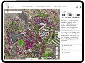
Project Spotlight & Case Studies
Green-Wood Cemetery App (iOS & Android)
We developed a custom mobile app for this 500-acre National Historic Landmark that brings landmark monuments, native species, and historical narratives to life. Visitors can explore the grounds, locate themselves on the map, and learn as they go.
U.S. National Arboretum – Mobile Explorer
Our collaboration with the Arboretum enhanced their Botanical Explorer tool by developing a mobile app with location services, exhibit information, predefined tours, and searchable plant records available on both Apple and Google Play stores.
New York Botanical Garden – Plant Tracker
This responsive web app gives visitors and staff access to over 140,000 living and non-living records. Search, filter, and explore plants across 25 garden areas with curated tours, photos, and key amenities.


Cultivate Your Garden's Digital Future
Partner with GIS experts who understand the unique needs of public gardens, arboretums, and botanical institutions.