As the April 2027 deadline for public sector web content accessibility compliance draws closer, state and local governments are under increasing pressure to assess and remediate their public-facing digital tools.
For Orange County, Virginia, that challenge landed squarely on the desk of GIS Manager John Watermolen, who needed to ensure the county's public-facing GIS applications were compliant with the Web Content Accessibility Guidelines (WCAG 2.1 AA) or at minimum on a clear path to compliance. With multiple applications in scope and a range of issues spanning keyboard navigation, color contrast, and missing screen reader labels, John needed a partner who understood both the legal requirements and the technical realities of GIS application development. Blue Raster brought both to the table.
Identifying the Right Approach
Compliance for each application looked different; some needed keyboard navigability tweaks, some had color contrast issues, and others were missing accessible labels for screen readers. But they all required careful review and remediation to meet WCAG 2.1 AA guidelines.
John needed a partner with both design experience and understanding of the law to identify non-compliances, but also technical GIS acumen to inform correct implementation. With accredited staff in the accessibility space (CPACC) and a reputation for high-quality app development, Blue Raster’s team of GIS and design professionals were the right people for the job.
A Thorough Assessment with a Clear Path Forward
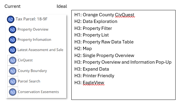
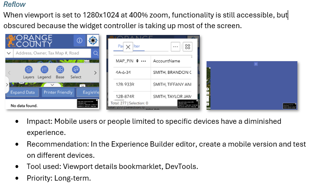
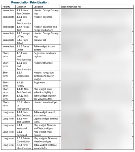
Blue Raster took a deep dive into 4 applications and 1 hub site, evaluating each one and its corresponding widgets, buttons, blocks, and pages against the web content accessibility guidelines. Our assessments don’t solely include descriptions and locations of each non-compliance, but rather a full picture of how to begin remediating each issue and long-term prioritization.
The assessment resulted in better insight for the county into the current state of their applications and how to move forward with remediation, improving user experience across the board. Blue Raster provides a consolidated list of items big and small to address with a hierarchy and suggested sequence for resolution. This means that for John, the path to compliance is now more navigable.
“The ADA audit not only helped us identify accessibility issues in our existing applications, but also provided a valuable framework moving forward. As we upgrade existing applications and build new ones, we now have a clearer understanding of accessibility requirements and can incorporate them into the process from the beginning.” -John Watermolen
Our ADA and Accessibility Compliance Services
Blue Raster's team combines GIS application development expertise with accredited accessibility knowledge, including staff holding the Certified Professional in Accessibility Core Competencies (CPACC) credential, to deliver thorough and actionable WCAG assessments.
We evaluate public-facing applications against WCAG 2.1 AA guidelines, identifying non-compliances across widgets, buttons, pages, and interactive elements, and translate those findings into prioritized remediation roadmaps that give clients a clear, practical path forward. Our assessments go beyond identifying issues; they provide the context and sequencing clients need to move toward compliance with confidence.


Start Your Path to Compliance
Ready to assess your GIS applications for ADA and accessibility compliance? Blue Raster's team of GIS professionals and accredited accessibility specialists can help you identify issues, prioritize remediation, and build a clear path to compliance. Contact us today.